Around West Texel
National Park Duinen van Texel is a nature reserve of 43 square kilometers and forms a sea of dunes as far as you can see over the entire west side of Texel. The area consists of five sub-areas, each of which is equally beautiful. Texel is loved by many animal species, animals like to come and find peace and space: the common seal and the gray seal have a great time along the coastline, rabbits and hares hop in the dunes where ermines and foxes hunt and as you're lucky, a playful white-beaked dolphin jumps out of the water. Texel is also a popular breeding and stopping place for many different types of birds, such as spoonbills and waders. When you hit the road, you have to cycle fourteen kilometers before you get to the first attraction. You will pass one of the four monuments on the island that bears the name Memorial Crash Lancaster Bomber. The stone with plaque is placed to commemorate a crashed Allied plane. Six kilometers away is a similar monument with the same name, but this refers to another crashed plane. At Landgoed De BONTE experience there are two attractive farms where old crafts are practiced. Here you can learn how the craftsmen in a soap factory, a brewery, a paper maker, a bakery, a candle factory and a distillery work to make their products. The next monument is also a war memorial. The Texel War Memorial that you see in Den Burg commemorates the many killed residents of Texel. The last monument you can view is a municipal monument in the shape of a polder mill. The meadow mill De Kemphaan was built to flood a bird sanctuary. In the fall of 2008, a blade broke off during a storm and several blades were damaged. In the summer of 2009, the mill was completely restored and made operational again. In 2013, the mill runs on a voluntary basis and is owned by the Vereniging Natuurmonumenten.
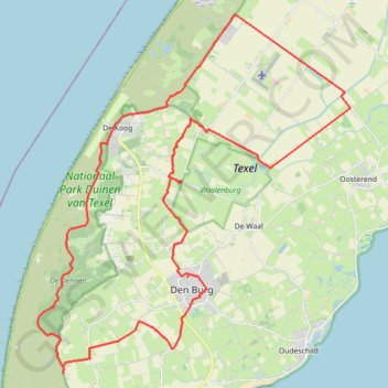
- Distance : 41.5 Km
- Dénivelé positif : 65 m
- Altitude maximum : 8 m
- Dénivelé négatif : 65 m
- Altitude minimum : -2 m
Carte interactive de l'itinéraire
Profil de l'itinéraire
- Distance : 41.5 Km
- Dénivelé positif : 65 m
- Altitude maximum : 8 m
- Dénivelé négatif : 65 m
- Altitude minimum : -2 m
À propos de cet itinéraire
Nom : Itinéraire Around West Texel, distance, dénivelé, altitude, carte, profil, trace GPS
Coordonnées : 53.03190 4.72611 53.13100 4.86977
Autres itinéraires de randonnée, VTT, course à pied et activités de plein air
Cliquez sur un itinéraire pour afficher ses statistiques, sa carte et son profil.
Nethen-Groningen
Belgique > Brabant wallon > Nivelles > Grez-Doiceau
Distance : 376.0 Km • Dénivelé positif : 416 m • Altitude maximum : 84 m